Our Antarctic trip of January 2011 had been planned and organized well in advance, and we’d planned a visit to Buenos Aires from the get go. Flight for this were booked about 10-11 months before. At that time the idea of 7lows hadn’t taken hold yet.
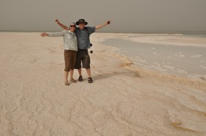
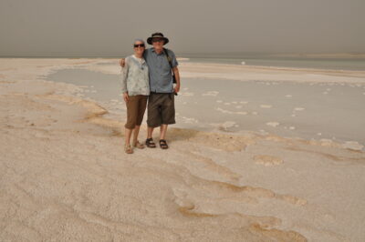
Stephen gifted me the 7lows website for my birthday in June of 2010. Turned out we’d been to the low point of North Americ in 2002. My already planned summer trip of 2010 included a trip to the Dead Sea, the Asian low point. We decided to adjust our Argentina/Antarctica plans to include a trip to Laguna del Carbón, since we would be in Argentina anyway.
Changing our flights was easy enough, once we’d looked into were we wanted to fly to. Río Gallegos seemed to be the best option. Car rental there didn’t present any problems either. The biggest issue turned out to be maps of the Laguna del Carbón area. We found a good road map but no detailed maps; obviously not an area high on the travel radar!
We started exploring the area on Google Earth. For hours we peered at the maps trying to discern trails, fences, gates, landmarks,… Anything that could be helpful in plotting a route accessible by 4WD from the main road to the Laguna. We entered tens and tens of waypoints which we then transferred to our Magellan SporTrak GPS unit. The next step was printouts of detailed, turn-by-turn maps of our planned route. This was after all a desert with extreme temperatures and we were not planning to get lost. We identified 4 possible entry points, ie.: for trails leading from the road in the general direction of Laguna del Carbón and we hoped that at least one of those would not involve a locked gate at the start or on route.
And Google Earth came through! Our self-made maps were spot on not only from the access point we ended up using, but also intersections with trails we didn’t take. We also had a good dose of luck in starting from the access poitn we did, but that story can be read in Trip Report.